The rise in Lake Victoria’s water level started on 1st October 2019 and consistently went up from 12.00 meters to the level of 13.32 meters as of 30th April 2020. This was a rise of 1.32 meters attained in only 6 months and the level was only 0.08 meters away from the highest level ever recorded according to a statement made by Uganda Media Centre on Friday, May 1, 2020.
Lake Victoria is a huge transboundary body shared by Kenya, Tanzania, and Uganda with about 23 rivers that bring water into the lake. Some of these rivers originate as far as Rwanda and Burundi and therefore when it rains in Burundi, water finds its way into Lake Victoria. There is, however, only one exit through River Nile at Jinja.


The rise in water levels for Lake Victoria also attracted regional and international attention since this water flows through South Sudan, Sudan, and eventually to the Mediterranean Sea through Egypt.

Along the path of the River Nile there are several towns and districts like Adjumani, and Moyo that are vulnerable to these floods and one of them is Obongi district where destructive floods submerged half of Obongi town council in northern Uganda and severely flooded extensions which included Obongi Town mosque, shops, homesteads and part of Obongi Town primary school. The floods cut off the road connecting Obongi to Moyo district while so many activities came to a standstill during that period where children could not access schools because others were crossing using the ferry, people could not access markets and the vulnerable ones had no option but use the risky small boats as means of transport and in the end resulted into overloading.
Impacts of the rising water level
Aspa Walugendo Martin, who works as a Marine Engineering Officer at Obongi district narrates the Ordeal of how the floods escalated until the ferry service that connects from Obongi to Adjumani district was grounded. “I have been here since December 2017. The floods started in Lake Victoria. First of all, here in Obongi being in the Northern region, we were just hearing about it. By the time we realized that the Kiyindi ferry had parked at Lake Victoria, then the Nakiwogo ferry. To us these were like stories and little did we know that the situation was becoming serious.”
“After one month, the Mbulamuti ferry had parked, the next time we could hear the Kyoga ferry had parked until it came to Masindi Port ferry which also parked and in about a period of five months it reached Albert Nile 1 also parked and after one month it also reached here. So, it was kind of a sequence, and we were told that this flood was coming from Lake Victoria.”
“So, when it happened here to the highest point that we could not even operate was in June 2020. And in July, we were forced to close down when the waters had covered the whole place and the neighbours started running away including the market people and many had nowhere to relocate. And eventually, many of them had to relocate to town.”
“These floods went as far as the mosque from one side and the other side, it went as far as one and a half kilometres. So, it became very impossible for our ferry to operate, and eventually we had to park. It is recent that the waters started declining so we were able to resume the operations this year in March 2023.”
 The ferry service is Obongi district/Photo by Sharon Muzaki
According to Alex Ameko, the District Community Development Officer, “It has been in history where they tell us that this kind of disaster happened about 60 years ago since they say history repeats itself. So, it’s like it has been repeating itself for a long time. Now that people have forgotten about it and settled around the riverbanks while the human activities have escalated everything.”
Henry Pastore Onzimai, the Senior Environmental Officer and the acting head of the department Obongi district attributes this whole flood tragedy to global climate change. “For the global climate change, there is rising water levels because of the imbalance of the water system. Water is stored in solid form which is in large quantities and the rising temperature leads to melting hence the intense rainfall which we experienced.”
“I think women are naturally the weak side in case of any disaster. Women were operating small businesses coming as far as Adjumani to buy some foodstuffs and take them back to the other side. These women were traveling with infants on their backs using canoes that were overloaded and safety was not guaranteed. In this region, women had to do the business side of it, rush back home, and prepare food for their families so they would not even pay attention to the risks attached to this, they continued to use the small boats as the only means of transport. While most women here, their livelihood was mainly smoking fish and fishmongers but their property was damaged and the fish smoking areas that were designated for them were already soaked in the waters, and had to look for other alternative means of survival,” Elizabeth Amen the Tourism Officer Obongi district talks mainly about how the disaster mostly affected women.
“When we went up to the ground to only find out that most houses that were affected by these floods were mainly for women as the head of the families thus their survival rate was minimal and they didn’t have enough to sustain their children. However, the scariest part was the transport part, how women faced difficulties crossing over to Adjumani to access health facilities. This was a disturbing dilemma,” Amen added.
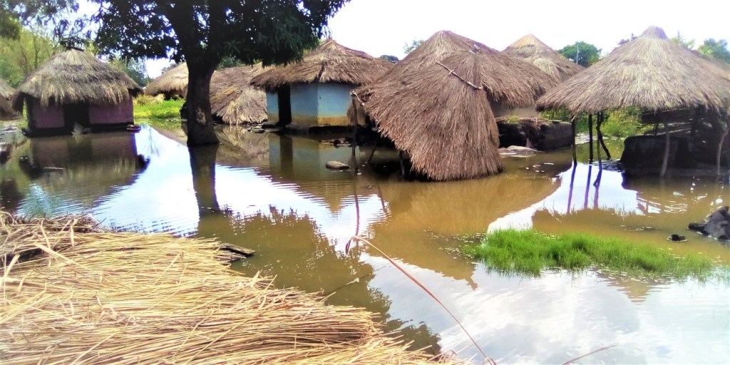
 Pictures of houses flooded in Obongi town council/Photos by Sharon Muzaki
Since then Obongi district has been vulnerable to extreme weather events. On the afternoon of Monday 20th March 2023, Belemaling and Nyawa villages in Zone 1 of Palorinya refugee settlement and Legu parish of the host communities received heavy rains as was also experienced in other adjacent areas.
Characterized by strong winds, this resulted in serious disaster in some communities of Belemaling and Nyawa villages which included flooding and destruction of family houses/shelter, Water, sanitation, and hygiene (WASH) facilities, and farmland among other social infrastructures.
Notably, In August 2022, the Palorinya refugee settlement was faced with a similar disaster during which it was estimated that in the areas of Basecamp, Zone I, Zone II, and Zone III West, approximately 302 Households were affected by heavy rains associated with heavy winds leaving their latrines and houses collapsed and farmlands damaged. This impacted significantly the socio-economic activities of the locals, and also access to various social service points/facilities like a water pumping point which was damaged in Zone III East which affected the water supply in that area.
The Lutheran World Federation (LWF) Uganda embarked on conducting a Rapid Flood Assessment to ascertain the extent of damage mainly on persons of concern which would help inform subsequent decision-making and response.

Pictures of affected houses by heavy rains in Zone 1 of Palorinya refugee settlement on 20th March 2023

Mitigation and adaptation plans
According to Ameko, there are government policies put in place. “One of the policies is about wetland protection which even the President of Uganda is very strong about. There are standards when you are settling along wetlands and rivers like this for about 200 meters away. That is government land in summary where activities are restricted. But yes, others are going back because they say they have nowhere to go,” he said.
“These are people who have taken some good years there. That is already where they see their livelihood. And here you are now telling this person to move. It’s not an easy thing. That’s why, despite the demarcation, so many are still moving back, you can see permanent houses built in wetlands.”
 A household settled at the buffer zone near the Ferry Landing Site/Photo by Sharon Muzaki
“Land belongs to different communities. Now because of that policy, it is about 200 meters away from the source and it is called the buffer zone which is reserved for natural habitats.”
According to the Joint Monitoring team findings, over 10 households have settled in the river bank-6 in Obongi Town Council and 4 in Ukuni East. Other forms of encroachment and degradation also exist such as bricklaying and cultivation of crops. Temporary structures and semi-permanent houses have been built in the buffer zones. The recommended buffer distances of 100 metres for Major River and 30 metres for wetlands is not being respected by the communities.
The degradation of Community Forest at Waka is very high evidenced by burning of trees, expansion of human settlement and cultivation in the forested areas, poor waste management is evident at the ferry landing site and Alibabito, there is evidence of widespread littering of solid wastes especially polythene bags and plastic bottles, vandalizing the pillars used to mark the buffer zone has been noted at the Obongi Town Council. Some pillars have been removed by the community members and thus further encroachment of the community in such areas and on spot advice has been provided to the communities during joint monitoring and communities are urged to move away from the buffer zones.
 A girl carrying a sack of charcoal in Obongi dirstrict/Photo by Sharon Muzaki
The joint environmental monitoring on compliance to policies and guidelines of environmental management was conducted on 29th March 2023. The main objective of joint monitoring and was to establish the extent to which communities/stakeholders adhere to environmental policies, guidelines and regulations as they interact with natural resources in the district with aim of fostering wise and sustainable natural resources use. River bank, wetlands, urban waste management, and management of the community forest at Waka were the focus of the monitoring and evaluation of environmental compliance.

Joint Monitoring team being briefed on demarcation of river bank at the ferry site
The monitoring and evaluation team includes the Physical planner, District Community Development Officer, District Planner represented by the Economist, Chairperson LCV represented by the Vice Chairperson, Deputy Chief Administrative Officer, Secretary Gender and Social Services, Team Leader LWF, District Engineer, Secretary for Environment-Obongi Town Council, Area MP represented by Personnel Assistant, Town Clerk, District Production Officer, LCIII Obongi Town Council, Resident District Commissioner, OPM, LWF, UNCHR and District Natural Resources Officer.
As a district has now embarked on creating awareness that is through sensitization and demarcating the buffer zones. “So, as I talk I think Obongi town Council has been demarcated. But the point is now implementation because when you do demarcation, that means people should be able to move away, and if they don’t move, there should be one strategy of implementing either resettling them somewhere, or telling them to move somewhere and the district, in collaboration with the Natural Resources Department are doing that,” he explained.

Joint monitoring team showing one of the pillars installed to mark buffer zone at Obongi Town Council/Photo by Sharon Muzaki
Across the Adujamani side, they are working on the road to another level raising it upwards. In the case of rising water, then water will be flowing from downwards. That is one way to prevent flooding. “With regards to climate change, we do not know how soon it will happen again. But let’s be prepared,” Ameko insisted
The District Community Development Officer who also said that not much has been done to prevent the community from resettling back to these prone areas not until when enforcement is done. It is supposed to be done by the Centers and not by the district thought Resident District Commissioners (RDC) were given authorities to do so. This also includes marines, environment police and National Environment Management Authority of Uganda.
Onzimai says his department has taken the initiative to sensitize communities about climate change so that they get to understand why this is happening and whatever they get to experience is because of climate change and the likelihood of occurrence of extreme events is very easy and so often may likely experience it again.

District Natural Resources Officer pointing at the poor solid waste management at the ferry site.
Joint monitoring engaging women vendors at the ferry site on good hygiene and sanitation practices/Photo by Sharon Muzaki
“We are advising them to plant the trees and some tree projects have been put in place with the support of the partners. We planted quite a number of hectares of trees in a year, an estimated number of around 80 hectares. Trees mitigate climate change because they absorb the carbon dioxide in the atmosphere and they stabilize the global climate system,” he added
Recommendations
There is always need to support the affected households and communities so as to help them recover from the shock, focusing on facilitating repair or reconstruction of broken-down shelter and latrines.
Conduct a joint multi-stakeholder assessment of the cause and effects of the flood, on a larger scope to ascertain the solutions to overcome the disaster in the near future.
Undertake a multi-stakeholder sensitization on community action planning to take charge in providing possible solutions to overcome the disaster while they are supported with the necessary tools. Also, this should incorporate awareness creation on the possible outbreak of water-borne diseases resulting from lack of proper facilities for disposal of human waste and also the existing stagnant water left in the community following the heavy rains.
With United Nations Development Programme (UNDP)’s support, a four days training on wetlands and river bank policies, guidelines and management, proper solid waste management, land use zoning and sustainable housing was organized for the Parish Environmental Protection Committees, Refugees Welfare leaders and sub county leaders in Palorinya and Itula Sub Counties. The training was facilitated by the District Natural Resources Officer; Forest Ranger and Staff Surveyor.
UNDP pilots and scales up interventions that respond to national priorities and emerging issues, and that advance progress in ending poverty, and promoting resilient, sustainable and risk-informed development with catalytic investments that accelerate implementation of the 2030 Agenda for Sustainable Development.

Training in river bank and wetlands management at Palorinya Sub County Head Quarters

Participants raising questions during training on wetlands, river banks, waste management, land use zoning and sustainable housing at Paalujo Parish Centre
Conclusion
While one would easily acknowledge the fact that Obongi district lies along the River Nile belt, which is prone to floods thus susceptible to the related destructions, there is need to take urgent action to support the affected households and communities especially in regards to restoring facilities that uphold their dignity.
However, long-term durable solutions should also be explored in an effort to combat future re-occurrence of the situation which significantly affects the wellbeing of the community members especially the persons of concern.
Four days training on climate change, adaptation and mitigation measures was organized for the Parish Environmental Protection Committees, Refugees Welfare leaders and sub county leaders in Palorinya and Itula Sub Counties. To strengthen the capacity of the local authorities in climate change, understanding human induced causes, effects and adaptation and mitigation measures and develop action plans for implementing adaptation and mitigation measures. The awareness was still possible due to UNDP funding.

LCIII Chairperson making closing remarks during training on climate change at Itula Sub County Headquarters

Training session going at the Catholic Church Idiwa-Morobi Parish